Research Article
Volume 2 Issue 5 - 2018
Land Degradation and Data Reporting Based on Soil Monitoring System in Slovakia
National Agricultural and Food Centre - Soil Science and Conservation Research Institute Bratislava, Slovakia
*Corresponding Author: Jozef Kobza, National Agricultural and Food Centre – Soil Science and Conservation Research Institute Bratislava, Slovakia.
Received: February 25, 2018; Published: March 16, 2018
Abstract
Soil monitoring system in Slovakia is consistently running since 1993. Its importance consists of providing soil information on changing with space and time as well the development of soil quality such as topsoil and subsoil. Soil monitoring network in Slovakia is constructed on ecological principles with particular emphasis on main soil types and subtypes, soil substrates, climatic regions, emission regions, polluted and non-polluted regions as well as various land use. Consequently, 318 monitoring sites on agricultural land in Slovakia were established. Concrete soil properties are evaluated according to the main threats to soil relating to European Commission recommendation namely, soil contamination, soil salinization and sodification, decline in soil organic matter, soil compaction and erosion. The most significant change has been determined by physical degradation processes like soil compaction and erosion where about 38.7 % of agricultural land is potentially affected by soil erosion in Slovakia. In addition, decline in soil organic matter and available nutrients indicate the serious facts on evaluation and extension of soil degradation processes during last period in Slovakia. Obtained measured data and required outputs are reported to Joint Research Centre (JRC) in Ispra (Italy) and European Environmental Agency (EEA) in Copenhagen (Denmark). Finally, soil monitoring system thus becomes a basic tool for protection of soils and sustainable land use as well as for creation of legislative not only in Slovakia, but in EU, too.
Keywords: Soil monitoring; Threats to Soil; Soil Degradation Processes; Slovakia
Introduction
Conception of European soil policy and soil protection strategy as well as its sustainable land use was established in Proposal of European Commission (EC) on the 6th Environmental Action Programme, which was accepted by European Council as well as European Parliament on the 22nd of July, 2002 where one of the basic strategies is just soil and monitoring of its consequent development. The main aim of soil monitoring system is to obtain the knowledge of the most current state and development of soil properties according to concrete threats to soil (e.g., soil erosion, soil compaction, soil acidification, decline in soil organic matter, soil contamination) in Slovakia, what is in harmony with european strategy of soil monitoring. There are permanently monitored important parameters in connection to recommendation of EC for evaluation of current state and development of soils (van Camp., et al. 2004).
Regulation concerning agricultural soils is the Act n. 220/2004 on protection of agricultural soils and agricultural land use (MPSR 2004) and Act n. 59 of Ministry of Agriculture and Rural Development of Slovakia from the 11th of March, 2013 (MPRV SR 2013) is important for the increasing quality of soils as well as to integrate decision sphere concerning the protection of agricultural soils against degradation.
Importance of soil monitoring system consists of providing actual and objective information on temporal trends in important soil properties of agricultural soils in Slovakia. In addition, obtained important current soil outputs are imported to JRC (Joint Research Centre) in Ispra (Italy) and to EEA (European Environment Agency) in Copenhagen (Denmark), as well.
Materials and Methods
Soil monitoring system in Slovakia has been running consistently since 1993 year. Soil monitoring network in Slovakia is constructed on ecological principles and includes the research data of all main soil types and subtypes, soil substrates, climatic regions, emission regions, polluted and non-polluted regions as well as various land use (Figure 1). There are 318 monitoring sites on agricultural and alpine land in Slovakia has been established. All soil monitoring sites are located in WGS 84 coordinates. The monitoring site represents the circular shape, with a radius of 10 m and an area of 314 m2. The standard depths of 0.0–0.10 m, 0.20–0.30 m and 0.35–0.45 m on soils under grassland and 0.0–0.10 m and 0.35–0.45 m on arable land are sampled, but the depth is adjusted to characterize the main soil horizons. The soil monitoring in Slovakia is carried out on 5 years repetitions. The most important soil indicators concerning threats to soil are included in the soil monitoring system in Slovakia according to the recommendation of the European Commission (EC) for united soil monitoring system in Europe (van Camp., et al. 2004).
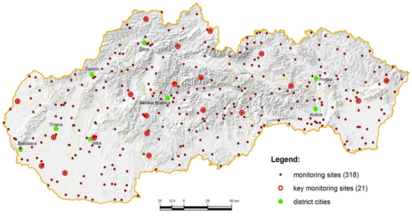
Figure 1: Soil monitoring network in Slovakia (Note: Monitored indicators of soil monitoring system according to threats to soil in Slovakia).
The most important soil indicators concerning threats to soil are included in soil monitoring system in Slovakia according to Recommendation of European Commission (EC) for unified soil monitoring system in Europe (van Camp., et al. 2004).
Soil erosion (on selected soil transects): 137Cs (gamaspectrometrically with high resolution); pH/KCl (exchangeable pH value was measured potentiometrically – ratio of soil to water 1:2.5); SOC (soil organic carbon; dry way using CN analyzer), P (according to Egner´s method, in Ulrich., et al. 1960), where soil samples were extracted by calcium lactate solution with pH value 3.7 and determined colorimetrically; K (according to Schachtschabel´s method, in Pirkl and Macháček, 2003), where available potassium was extracted using ammonium acetate and ammonium oxalate solution with pH value 6,0-6.2. Concentration of potassium was determined by atomic spectrophotometry; texture (according to USDA-NRCS, 2010)
Soil compaction: bulk density (ςd); porosity (P); maximum capillary water capacity (wKMK) measured in 100 cm3 cylinders; texture (according to the work Uniform analytical procedures for soil (Kobza., et al. 2011).
Quantitative and qualitative composition of soil organic matter: SOC, Nt (total nitrogen; dry way using CN analyzer), CHA/CFA, Q46 according to Kononova & Beľčikova, in Kobza., et al. 2011).
Soil contamination: Cd, Cr, Pb, Ni, Zn, Cu, As Se, Co (extracted with aqua regia, using the mixture of concentrated HCl and HNO3 in ratio 3:1), Hg (total content using the analyzer AMA 254) (Zbíral, 2003, Kobza., et al. 2011).<
Methodical and analytical procedures in more details have been realized according to the work Uniform analytical procedures for soil (Kobza., et al. 2011). Statistical analysis and data evaluation was carried out using the GIS.
Results and Discussion
Soil erosion
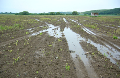
Soil erosion belongs to the most environmental problems and the most extended degradation process in Slovakia. Erosion is measured on soil transects using 137Cs profile distribution. In addition, the area of soil erosion distribution is determined by using of erosive predictive model where the USLE equation is included (Wischmeier and Smith, 1978). This interactive and predictive erosive model was created for farmers. They can find this model on www.podnemapy.sk. This application is very helpful for the information on soil erosion intensity and its area distribution. According to our results about 38.7 % of agricultural soils is potentially affected by soil erosion in Slovakia (including abandoned soils) (Table 1).
Soil erosion belongs to the most environmental problems and the most extended degradation process in Slovakia. Erosion is measured on soil transects using 137Cs profile distribution. In addition, the area of soil erosion distribution is determined by using of erosive predictive model where the USLE equation is included (Wischmeier and Smith, 1978). This interactive and predictive erosive model was created for farmers. They can find this model on www.podnemapy.sk. This application is very helpful for the information on soil erosion intensity and its area distribution. According to our results about 38.7 % of agricultural soils is potentially affected by soil erosion in Slovakia (including abandoned soils) (Table 1).
| Erosivity categories (soil loss) | Area in ha | % of farm land |
| Non or slight (0–4t/ha/year) | 1 213 092 | 61.3 |
| Medium (4–10t/ha/year) | 205 487 | 10.4 |
| High (10–30t/ha/year) | 292 266 | 14.8 |
| Extremly high (>30t/ha/year) | 266 769 | 13.5 |
| Total | 1 977 614 | 100.0 |
Table 1: Potential water erosion distribution on agricultural land in Slovakia.
*ha indicates hectare
Soil compaction
Soil compaction is monitored along with soil monitoring network, but only on arable land (topsoil and subsoil are included) on the basis of measured physical indicators (bulk density, porosity and texture).
Soil compaction is monitored along with soil monitoring network, but only on arable land (topsoil and subsoil are included) on the basis of measured physical indicators (bulk density, porosity and texture).
From among the soil textural composition the most risk soils to soil compaction are heavy to strongly heavy soils. More than 20% of agricultural land area in Slovakia is covered just by these soils. In addition, affected soils to soil compaction contain non-permeabile soil horizon for rainfall water (e.g. texturally diferentiated soils - Luvisols). On the other side the soils with high groundwater level (Gleysols, Solonchaks and Solonetz, as well). These soils cover more than 10% of agricultural land area.
Decline in soil organic matter
Quantitative and qualitative indicators of soil organic matter (SOM) are permanently monitored in soil monitoring network in Slovakia. Originally, after slight decline in soil organic carbon (SOC) on the beginning of soil monitoring system in Slovakia (1993), its increase has been indicated on all arable soils during last period. It could be probably caused by subsidies of Slovak Government for increasing of soil organic matter in soil.
Quantitative and qualitative indicators of soil organic matter (SOM) are permanently monitored in soil monitoring network in Slovakia. Originally, after slight decline in soil organic carbon (SOC) on the beginning of soil monitoring system in Slovakia (1993), its increase has been indicated on all arable soils during last period. It could be probably caused by subsidies of Slovak Government for increasing of soil organic matter in soil.
Qualitative indicators CHA/CFA, Q46 are without significant trend. However, the measured values are characteristic for the concrete soil type as well as for the chemical structure of humic acids (HA). These indicators seem to be a result of soil genesis.
Content of soil organic carbon (SOC) in soils is largely conditional of soil genesis. On cultivated soils, mainly on arable soils, content of SOC is limited by intensity and depth of cultivation what affect increasing of mineralization of soil organic matter (SOM). Average values of SOC in arable Slovak soils ranged between 1–2.5%. When converted to humus (conversion coefficient 1.724) it is represents moderately until good content of soil humus. The lowest values of soil organic carbon are characterized for Regosols and the highest values of SOC for Mollic Fluvisols.
Recently, depending on soil types, development of SOC level on arable soils is quite different. Gradual increase of SOC concentration is clear mainly on Mollic Fluvisols and Haplic Fluvisols. On Rendzic Leptosols average value of SOC after previous decrease reached substantially increase to the level of initial state. On Chernozems and Cambisols SOC values is maintained at the same level as in the previous cycle. On Planosols and Stagnic Luvisols slightly reduction of SOC content was observed, which was not statistically significant. The relatively highest reduction of SOC level was determined on Regosols.
Soil salinization and sodification
On the basis of obtained results it was indicated that these processes are running more or less in paralell, but the sodification process seems to be dominant under soil-climatic conditions of Slovakia (mostly in south-western and south-eastern part of Slovakia) – Kobza., et al. (2014). There are about 3 thous. ha of salined soils in Slovakia (0.15% of agricultural land of Slovakia).
On the basis of obtained results it was indicated that these processes are running more or less in paralell, but the sodification process seems to be dominant under soil-climatic conditions of Slovakia (mostly in south-western and south-eastern part of Slovakia) – Kobza., et al. (2014). There are about 3 thous. ha of salined soils in Slovakia (0.15% of agricultural land of Slovakia).
Salinization is a process of accumulation of neutral natrium salts in soil, above all NaCl and Na2SO4. Indicator of salinization process is a total content of water soluble salts in soil and electrical conductivity of saturated soil extract (ECe).
Sodification is a process of fixation of exchangeable sodium on sorption complex of soil. This process is influenced by presence of alkaline salts in soil, above all Na2CO3, NaHCO3 and Na2SiO3. Indicator of sodification process is the content of exchangeable sodium in sorption complex of soil (ESP) and pH value.
Soil contamination
The significant change in concentration of inorganic contaminants (Cd, Pb, Cu, Zn, Cr, Ni, Co, Se, As, Hg, F) was not indicated during monitored period of 25 years.
The significant change in concentration of inorganic contaminants (Cd, Pb, Cu, Zn, Cr, Ni, Co, Se, As, Hg, F) was not indicated during monitored period of 25 years.
Concerning soil contamination evaluation the various impacts on soil could be described as follows:
- influence of man (industry, agriculture, municipal waste material, etc.)
- influence of geochemical anomalies
- mixed influence
Influence of man on soil contamination was the most significant after the 2nd World War and especially during industrial period in the 2nd half of 20th century in Slovakia (former Czechoslovakia). Later, after 1990 year development of soil contamination is slight without significant change. It means that the soils which were contaminated in the last, unfavourable hygienic state of these soils is practically the same also at present time (less than 1% contaminated soils of soil cover is calculated in Slovakia).
Geochemical anomalies occur especially on volcanic and crystalline rocks mostly in mountainous regions, less in agricultural land. The most extended areas of geochemical anomalies occur in Štiavnické vrchy, Low Tatras and Slovenské Rudohorie Mountains. These regions are characteristic with high to very high concentrations of risk trace elements, especially heavy metals in all soil profile (Cd, Pb, Cu, Zn, As, Hg).
Soil monitoring database of Slovakia and data reporting
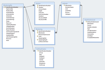
Database of soil monitoring allows to create the main data on the monitoring sites of agricultural land and to prepare them for further processing through specialized programmes (statistical programmes, spreadsheets and other databases). Position information provides a link to the geographical information systems, and thus opens room for the further spatial analysis. User interface database also allows insert and view data, their selection and print a table of data stored on the soil profiles.
Database of soil monitoring allows to create the main data on the monitoring sites of agricultural land and to prepare them for further processing through specialized programmes (statistical programmes, spreadsheets and other databases). Position information provides a link to the geographical information systems, and thus opens room for the further spatial analysis. User interface database also allows insert and view data, their selection and print a table of data stored on the soil profiles.
Structural harmonization of database and rebuilding the original structure of the geodatabase and moving on ORACLE platform are processing in this time. In addition, it also has built a network interface database for fulfilling the new data but the main functional services for publishing spatial information of soil monitoring, which are on line with OGC -WMS & WFS specification to define the standard reporting data structures.
Integrated soil database in Slovakia allows to us to increase the information value of soil monitoring system. The application of various digital layers (land use database, ortophotomaps of landscape, LUCAS, soil monitoring database – red point is a monitoring site) can better explain actual soil change caused by different and changed land use.
In the following Figure 4 the ten partial monitoring systems of environment in Slovakia has been described. The obtained data are regularly reported to the European Environment Agency in Copenhagen (Denmark) and Joint Research Centre in Ispra (Italy).
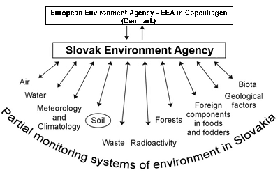
Figure 5: Implementation of soil monitoring system with monitoring of environment in Slovakia and EU.
Conclusion
The soil monitoring system supports the comparable and objective data on better is current state and development of soils in Slovakia. The obtained results are useful above all in decision-making sphere (e.g. for soil protection) and in various branches of national economy as well as in research institutes and universities with environmental education. In addition, reporting of obtained data to EEA in Copenhagen (Denmark) and to JRC in Ispra (Italy) contributes to creation of important outputs concerning actual state and development of soil cover in EU.
The most significant change has been determined by physical degradation processes – soil compaction and erosion where about 38.7% of agricultural land is potentially affected by soil erosion in Slovakia. In addition, decline in soil organic matter indicate the serious facts on evaluation and extension of soil degradation processes during last period in Slovakia.
Finally, soil monitoring system thus becomes a basic tool for protection of soils and sustainable land use as well as for creation of legislatives not only in Slovakia, but in EU, too.
Acknowledgements
We would like kindly to thank to Ministry of Agriculture and Rural Development of Slovakia for the financial support of this project.
We would like kindly to thank to Ministry of Agriculture and Rural Development of Slovakia for the financial support of this project.
References
- Kobza, J., et al. “Jednotné pracovné postupy rozborov pôd (Uniform analytical procedures for soil)“. SSCRI Publishing Bratislava (2011): 136.
- Kobza J., et al.“Monitoring pôd Slovenskej republiky (Soil monitoring of Slovak Republic)“. SSCRI Publishing: Bratislava (2014): 252.
- MPSR. “Ministry of Agriculture. Act No. 220/2004 on protection and agricultural land use”. Annex 2 under Part 96 (2004):
- MPRV SR. “Ministry of Agriculture and Rural Development”. Act No. 59 from 11.3.2013 (in Slovak) (2013):
- Pirkl J and Macháček V. “Analýza půd I. Jednotné pracovné postupy (Analysis of soil I. Uniform analytical procedures). ÚKZUZ Brno“. Czech Republic (2003): 111-113.
- Ulrich B., et al. “Zur analytischen Bestimmung von Gesamtphosporsäure und laktatlöslicher Phosphorsäure in Bodenproben”. Die Phosphorsäure 20 (1960): 340-347.
- USDA-NRCS. “Keys to soil taxonomy, 10th ed”. USDA-NRCS (2010): 332.
- Van–Camp L., et al.“Reports of the Technical Working Groups Established under the Thematic Strategy for Soil Protection“. Office for Official Publications of the European Communities, Luxembourg (2004): 872.
- Wischmeier WH and Smith DD. “Predicting rainfall erosion losses – Guide to conservation planning“. Agricultural Handbook 537, (USDA Publishing: Washington) (1978): 58.
- Zbíral J. “Analýza půd II. (Soil analysis II.), ÚKZÚZ Brno“. Czech Republic (2003): 119-121.
Citation:
Jozef Kobza., et al. “Land Degradation and Data Reporting Based on Soil Monitoring System in Slovakia”. Innovative
Techniques in Agriculture 2.5 (2018): 460-466.
Copyright: © 2018 Jozef Kobza., et al. This is an open-access article distributed under the terms of the Creative Commons Attribution License, which permits unrestricted use, distribution, and reproduction in any medium, provided the original author and source are credited.


















 Scientia Ricerca is licensed and content of this site is available under a Creative Commons Attribution 4.0 International License.