Case Report
Volume 3 Issue 4 - 2019
Non - Spatial Participatory Social Mapping for Dairy Farming Livelihood Analysis
1Risk and Vulnerability Science Centre, Walter Sisulu University, South Africa
2Institute for Rural Development, University of Venda, South Africa
3Directorate of International Relations, University of Venda, South Africa
2Institute for Rural Development, University of Venda, South Africa
3Directorate of International Relations, University of Venda, South Africa
*Corresponding Author: Kabiti HM, Risk and Vulnerability Science Centre, Walter Sisulu University, Nelson Mandela Drive, P Bag x1 Unitra, Mthatha, Eastern Cape, South Africa.
Received: September 07, 2018; Published: April 04, 2019
Abstract
Participatory social maps are rich with data relating to a particular phenomenon in a locality. Construction of meaning from the data is achieved through data analysis which can be challenging in the event that more than one map is produced. In this paper, focus is placed on the application of non-spatial participatory social mapping in understanding communal dairy farming livelihood strategy in Nharira Zimbabwe. Furthermore, insights on how analysis of participatory social map can be done given at least two maps drawn by different groups from the same community, are provided in this paper. The paper concludes that consolidated meaning can be derived from social maps without losing the voice and context of the people who produced the map. Participatory mapping process indicated that participation in communal dairy farming enhances all the livelihood capitals of the household. However, there is need to quantify the extent of contribution so as to better inform policy.
Keywords: Communal farming; Livelihood capital; Methodology; Participatory Rural Learning (PRL); Qualitative data analysis
Abbreviations: PLA: Participatory Learning and Action;
Introduction
Participatory mapping is used as a visual qualitative research question interrogation method (Panek, 2015). Mapping is commonly used to depict the spatial distribution of various features within a locality. However, participatory social mapping introduced the visual presentation and connections of mental processes shaped by local knowledge and experiences, without necessarily including the geographic distribution of the features represented (van Biljon & Marais, 2017). Even though spatial distribution is sometimes not factored in, participatory social maps depict relationships, culture, history, trends and associations experienced by the people drawing it. Rockloff and Lockie (2004), indicates that participatory social mapping enables a multi stakeholder understanding of an issue, whilst maintaining the different values held by each group. Over the past years, the use of participatory mapping in different regions of the world in social research has been spreading due to the richness of the data collected in this manner (Coberrt, 2009).
Participatory mapping is the visual presentation of the perceptions of a group of people with regards to a phenomenon (Chambers, 2008). Participatory social maps tell stories, bring out conversations, and show the way of living and understanding of a community. The maps are constructed using various metaphors depending on the choice of the originator. Social map metaphors allow for the representation of culture, traditions and local history, which cannot be easily represented by spatial maps (Walker & Peters, 2001). Constructing and bringing out an understanding of the map is done in a participatory manner whereby shared knowledge is generated. These kind of maps are important in decision-making, strategy formulation and evaluation of programs. Map development process allows for deliberation among the participants, with little restrictions on the way the map should be constructed in the process giving leeway for participant innovation. Participatory social mapping is engaging and allows for innovation particularly when working with semi or illiterate participants. It gives participants the space to make meaningful contribution to the subject under discussion and ensures representation of various stakeholders (Pain, 2004). This is an important factor in development related instances that promote community engagement. The process gives participants an opportunity to reflect on their thoughts, feelings and realities they experience.
From the name, it is clear that these maps are constructed by a group of people working together. This is because they fall under a family Participatory Learning and Action (PLA) methodologies, which entrust the process of appraisal and analysis to the people involved (Chambers, 2008). Participatory social mapping has been applied in various disciplines such as public health (Igras, Diakité, & Lundgren, 2017), environmental studies (Moorea, Brown, Kobryn, & Strickland-Munro, 2017), agriculture (Fagerholm & Käyhkö, 2009) to understand diverse features of a community (Emmel, 2008). A community might gather around to come up with a map as a way of understanding a particular issue or project at hand. In such studies, single map is produced by a group of participants in a participatory process. Full analysis of the map is done on site through discussing the futures represented by a map. However, further subgroup divisions can be formed to ensure various map versions on the same aspect for the purpose of enriching the data and identifying patterns. Consequently, further analysis of the maps will need to be done in order to amalgamate the data from all the maps. This paper delves into the analysis of a number of social maps addressing the same issue produced by different segments of a community with the aim of generating an understanding on a phenomenon (in this case communal dairy farming).
According to Coberrt (2009), there is need to evaluate participatory maps to ensure that they represent the views of a community. Unlike other kinds of mapping, it is challenging to determine if the information displayed on a participatory social map is complete or accurate. This is because the information represented is not constant for example in the case of participatory spatial mapping or seasonal mapping where particular feature occurs at the same time or place. Participatory social mapping focuses on the views of the participants that cannot be labelled as incorrect or inaccurate.
Understanding rural livelihoods cannot be achieved without the involvement of the involved people. Participatory social mapping provides a pathway of engaging the rural communities in generating knowledge on rural livelihoods. Communal dairy farming one of the rural livelihood strategies practices by households in Nharira, Zimbabwe, through an organized cooperative model (Ngongoni, Mapiye, Mwale, & Mupeta, 2006). This paper addresses how participatory social mapping can be applied to generate understanding on a livelihood strategy (in this case smallholder dairy farming) effect on livelihood capital ownership of participating household. The sustainable livelihood framework provides a pathway for exploring deeply the ways and conditions in which poor households make a living (Chambers & Conway, 1992; Carney, 1998). This paper focuses on the core feature of the framework which is the five livelihood capitals (Kristjanson, Radeny, Baltenweck, Ogutu, & Notenbaert, 2005). Participatory social mapping is used to understand the changes to livelihood capitals as a result of communal dairy farming. Prior studies which applied mapping to understand livelihoods focused on strategies adopted (Kristjanson, Radeny, Baltenweck, Ogutu, & Notenbaert, 2005). A gap exists on the use of participatory social mapping in understanding the livelihood capital changes as a result of dairy farming.
Materials and Methods
Participatory Social Mapping: The process
This paper uses a case study of mapping that was carried out in Nharira, Zimbabwe by a group of communal farmer as an example. The study focused on identifying the contribution of dairy farming to livelihoods of participating household.
This paper uses a case study of mapping that was carried out in Nharira, Zimbabwe by a group of communal farmer as an example. The study focused on identifying the contribution of dairy farming to livelihoods of participating household.
Materials used
Successful social mapping is facilitated by availability of appropriate resources for the process (Coberrt, 2009). Materials used for the exercise encompassed venue, stationery (A1 flip charts, colored markers, sticky tape, pens, pencils, colored flags and sticky mini note pads), participatory social mapping guide, and facilitator, voice and video recorder.
Successful social mapping is facilitated by availability of appropriate resources for the process (Coberrt, 2009). Materials used for the exercise encompassed venue, stationery (A1 flip charts, colored markers, sticky tape, pens, pencils, colored flags and sticky mini note pads), participatory social mapping guide, and facilitator, voice and video recorder.
Participatory mapping process requires participants to be supplied with a lot of stationary to enable them room for innovation (Kumar, 2002). The participants were allowed to use other materials beyond the stationary availed by the research team. These included include sticks, stones, leaves and papers. Such materials enable the elaboration of context and culture of the people drawing the map.
The venue of mapping sometimes determines the resources needed. For example, if mapping is to be carried out in an open space or under a tree, a flipchart stand might be a necessity rather than when the exercise is being done in a hall with surfaces where the charts can be attached to the wall. Additionally, the venue should be conducive for deliberations, that is with enough room to accommodate all participants and shielded from external disruptive noises.
Planning for participatory mapping needs to take cognizance of the people participating and their context. According to (Peck, Olsen, & Devore, 2015) context is vital because it gives a problem a meaning. Not so much can be done accurately without understanding the operational context. Likewise, context is important in determining appropriate materials that work better with the people under given circumstances. The materials should be adapted to the needs of the participants and their capabilities. This is particularly important when considering the participatory mapping guide and literacy levels of the participants. In this case, the mapping guide clearly outlined the purpose and the activity which was to be done and was written in a language which all the participants are conversant with. Facilitators played a crucial role in clarifying the research question and the mapping process. Facilitators were well trained beforehand and had clear understanding of their role in the participatory mapping process. During the mapping exercise, groups had minimum interference from the facilitator to inter participant interaction.
Use of equipment such as voice recorders and video camera was done after done after getting consent from the participants. Voice recording during participatory mapping process is critical for complementing field notes and picking verbatim quotes when analyzing the maps.
Instructions
It is important to have a clearly articulated set of guidelines on how to carry out the participatory mapping exercise. Poorly framed guidelines may compromise the effectiveness of mapping exercise as participants will be confused about what is required from them. Sometimes it is necessary to translate the guide into local language for effective communication purposes especially when dealing with participant who are not so conversant in English.
It is important to have a clearly articulated set of guidelines on how to carry out the participatory mapping exercise. Poorly framed guidelines may compromise the effectiveness of mapping exercise as participants will be confused about what is required from them. Sometimes it is necessary to translate the guide into local language for effective communication purposes especially when dealing with participant who are not so conversant in English.
In the case of Nharira where the study was undertaken, participants were representatives of communal dairy farmers. Study participants comprised of four men, five women and five youth who were from communal dairy farming households. These were recruited through an open invitation to all members of dairy farming households in Nharira. Participants were divided into mapping groups according to age and social class. Groups were made up of between four and five participants depending on the number that turned up. Additionally, small groups were opted for so as to ensure an enabling environment for participation. Large groups (more than twelve participants) often harness the views of domineering characters whilst sidelining the opinions of the more introverted ones (Carrey & Asbury, 2016). Emmel (2008), shares the same sentiments that small homogenous groups produce better results in participatory mapping exercise.
In the Nharira case study three groups engaged in a participatory manner to produce three social maps that represent what dairy farming means to their livelihoods and the way they live as shown in Figure 1, 2 and 3. The participants had to decide on how their map would represent their view. Three facilitators handled the three groups. Facilitators worked with the groups to go through the instructions after which they stepped back to allow the discussions to be done freely. However, the facilitators would monitor the proceedings from time to time.
With permission from the participants, discussions during mapping were recorded. The recordings gave an additional explanation of map metaphors of features. However, sometimes the participants may not feel very comfortable to be recorded whilst engaging in discussion. Clarification of the reason behind the recording usually helps to avert this challenge. After drawing the maps, participants were given time to share their product with the rest of the group in a plenary session. During the presentations, interpretations given by the group about their map were recorded. Follow up questions were asked so as to get clarity on the map metaphors.
Data Analysis
Given three maps developed by different social groups on the same issue, it can be a mammoth task to draw out a consolidated analysis data. Qualitative data analysis is the systematic process of bringing out interpretations, explanations and linkages to actions, interviews, maps and field notes in relation to the context (Flick, 2015). Data analysis ensures rearrangement and packaging of the data into meaningful categories.
Given three maps developed by different social groups on the same issue, it can be a mammoth task to draw out a consolidated analysis data. Qualitative data analysis is the systematic process of bringing out interpretations, explanations and linkages to actions, interviews, maps and field notes in relation to the context (Flick, 2015). Data analysis ensures rearrangement and packaging of the data into meaningful categories.
Participatory social mapping embeds analysis in the process, though it is not comprehensive. Data analysis starts when the participants give an annotation of their maps during a plenary session. This plays also contributes to the validation of the data provided (NOAA, 2015). During the presentations, the groups chose a rapporteur to explain the symbols and metaphors within their map. The symbols and metaphors took various shapes and forms as depicted in Figure 1, 2 and 3. The rapporteurs pulled out the reasoning behind selected symbols, metaphors, size color and shape, elaborating on the linkages embedded in the map.
This analysis was crucial for achieving better understanding of the social maps produced. It helped to maintain the voice and understanding of the participants who developed the map. It is important for participatory mapping interpretations to retain the meaning given by the people who produced them. Through presentation, the groups clarified and refined the views represented on the maps. The researcher also had the opportunity to ask follow-up questions for further clarity.
At the end of the day, the researcher had a number of maps (three), recordings of discussions and presentation elaborations for use to answer the research questions. Figure 1, 2 and 3 shows the maps that were produced by the three different groups. The different groups took various dimensions in portraying their understanding of the contribution to dairy farming. These differences created need for further analysis. The second kind of analysis happened when the researcher pulled out all the output of the mapping process in order to come up with in depth meanings of the results. This was done through identifying themes and grouping the map features and annotations accordingly.
Efforts to bring out the shared understanding from the maps calls for analysis of data produced. The first step of the second data analysis process was to thoroughly study all the maps produced one by one whilst noting down the themes emerging. The maps were studied in conjunction with the respective field notes, and discussion recordings. Field notes and discussion recordings act as guidelines for better understanding of map features Coberrt (2009). In addition, discussion recordings are richly loaded with experiences and perspectives, which contribute to better understanding of the maps produced. Discussion are important for pointing out the commonalities and differences within the maps. Listening and reading through the notes for a number of times ensured that the researcher is immersed into the data. Moreover, this ensured that participants’ voice was not lost in the process. In this case, the themes identified were the livelihood capitals namely financial, physical, social, economic and human. This means that all the identified metaphors were classified under the themes. Identified themes were in line with the objectives or purpose of the exercise. Particular attention was given to the size, color and shape of the features of the maps in relation to the explanation given. These usually depict the value elements embedded in the feature showing their popularity.
After identifying emerging themes, identified features of the maps were jotted down according to the theme that they fell under. Ideally, drawing out a table makes the tallying of the map features and respective group easy. The table clearly outlined the themes that emerged from all the maps cross tabulating them with the specific feature and the groups that identified them. After compiling a list of all the features, reading through helped to identify the need to merge the related ones. Tallies were calculated to give a picture on the frequency of these features.
After pulling out the map features, relook at the maps to check for any outstanding data not captured on the table was done. This was to enable the researcher to identify other important aspects or relationships that could have been depicted on the map unconsciously. Such can bring out other important aspects and relationships that might have been omitted during map development and presentations.
Whilst listening to the voice and video recording of the mapping proceedings, it is necessary to pick verbatim quotes, which are a good representation of the emotions and passion behind the issue under discussion (Cornwall & Pratt, 2003). Having all the data in hand, it is necessary to relate the description and features identified to theory. This is done so as to generate a better understanding of the phenomenon under study.
All this should be done in ethical manner. Ethics in participatory social mapping cannot be understated (Coberrt, 2009). Participatory social mapping strength lies in getting views in a participatory manner. For this to be achieved and maintained, ethical standard of research should be adhered to, particularly when collecting, analyzing and presenting data.
Results and Discussion
Maps produced by the communal farmers unveiled various dimensions in which dairy farming affects the livelihood capitals of the participating households Looking at the maps in Figure 1,2 and 3, there are clearly visible distinctions across the three, though they were produced in response to the same question. This gives a general overview of the maps. The map produced by the youth had a more systemic approach, focusing on the linkages in the various processes that were supported or affected by dairy farming at household level (Figure 1). These were more aligned to natural capital as compared to the other groups. However, the annotation provided on the map went beyond natural capital, to include other forms of livelihood capital. The map had few physical capital related features, as justification they indicated that, “As youth, we cannot draw houses because we do not have them as yet”.
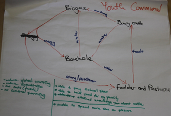
Figure 1: Map drawn by youth on contribution of dairy farming to livelihoods produced by communal dairy farmers in Nharira, Zimbabwe.
The map produced by the group of men was more attentive to household structures and how they have changed as a result of dairy farming, with an emphasis on the distribution of various resources, assets and infrastructure across and in relation to the farm (Figure 2). The map shows the equipment which households now own as a result of dairy farming. These equipment makes dairy farming easily manageable. Household physical assets improvements as a result of dairy farming were the major highlights on the map. In contrast, the map drawn by women was a compilation of different aspects affected by dairy farming as independent features (Figure 3). The map produced by the women’s group represented the contribution of dairy farming to livelihood capital in a balanced way. All the livelihood capitals were fairly represented.
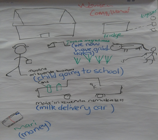
Figure 2: Map drawn by women on contribution of dairy farming to livelihoods produced by communal dairy farmers in Nharira, Zimbabwe.
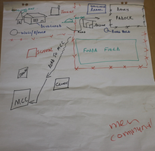
Figure 3: Map drawn by men on contribution of dairy farming to livelihoods produced by communal dairy farmers in Nharira, Zimbabwe.
Even though the participants took different angles to expressing their perceived contribution of dairy farming households, there are a number of similarities in the specific points that they were putting across. Furthermore, the different angles taken give a broader perspective on the subject, showing the interests or areas of concern of the particular group.
Household Assets
Physical capital
From the maps drawn by men and women, it is evident that features representing physical capital are the most dominant. The groups indicated that numerous physical changes are visible around the farm houses. The maps depicted improved housing as represented by the building materials and size. The new houses were bigger, with asbestos roofing and proper ventilation (windows) as compared to the thatching on houses before practicing dairy farming. Men group articulated the transitions very well by showing the houses before and after the contribution of dairy farming. Next to the farm house there was evidence of the presence of a pit toilet which is another important asset which contributes to the wellbeing of household members. One of the participants expressed this in the following manner, “Some of us did not have proper toilets. We managed to build nice toilets in such a way that if I visit a household where there is no toilet, I will not consume the milk they produce”.
From the maps drawn by men and women, it is evident that features representing physical capital are the most dominant. The groups indicated that numerous physical changes are visible around the farm houses. The maps depicted improved housing as represented by the building materials and size. The new houses were bigger, with asbestos roofing and proper ventilation (windows) as compared to the thatching on houses before practicing dairy farming. Men group articulated the transitions very well by showing the houses before and after the contribution of dairy farming. Next to the farm house there was evidence of the presence of a pit toilet which is another important asset which contributes to the wellbeing of household members. One of the participants expressed this in the following manner, “Some of us did not have proper toilets. We managed to build nice toilets in such a way that if I visit a household where there is no toilet, I will not consume the milk they produce”.
All the participants identified presence of bio digesters at households. Consequently, energy from the bio digester is used to power household assets such as fridges, televisions and boreholes as shown on the maps. The map produced by the youth placed emphasis on the importance of a borehole at the households. This is evident by the connectedness of all the other map features to the borehole. As they discussed, they highlighted that, “We no longer follow the rainy season as we have water. Some are even worried that there is no rain but I have rain from the borehole”. This statement indicates the important role which the presence of borehole plays.
The maps also showed that dairy farming has made contribution to the purchasing of motor vehicles. This was raised by the women group. These vehicles are useful for transportation of milk to the dairy in addition to the basic functions of a car at a household. Even though it was the women’s group which identified a car, adult men group went on to show the presence of a road linking households to Nharira milk collection centre. A road is an infrastructure which benefits the participants beyond the household, but as a community. The participants further pulled out physical equipment related to dairy farming which are now present at household. These include milking parlor, milking cans and well fenced paddocks. Men also managed to show the transition from using the “indigenous kraals”, to paddocks.
Natural capital
Youth produced a map which appreciated a lot of the contribution towards natural capital. All the groups of participants agreed that production of biogas energy was a benefit derived from dairy. However, youth went on to highlight a further benefit from biogas which is the reduction of deforestation as farmers no longer rely heavily on firewood as an energy source. This can be viewed as a ripple effect benefit from dairy farming. The youth identified cow dung, which is a byproduct of dairy farming, as another positive contribution to livelihoods. Cow dung is important as a fuel for energy production through the bio digester and for improvement of soils. During the production of biogas, slay produced is also used as a fertilizer to soil (Gaur & Suthar, 2017). They also pulled out the reduction of global warming as a positive contribution brought about by the use of cow dung for biogas production. One of the youth participants expressed this in the following manner, “Biogas is reducing global warming. Too much cattle dung causes global warming however using it to produce biogas reduces this”.
Youth produced a map which appreciated a lot of the contribution towards natural capital. All the groups of participants agreed that production of biogas energy was a benefit derived from dairy. However, youth went on to highlight a further benefit from biogas which is the reduction of deforestation as farmers no longer rely heavily on firewood as an energy source. This can be viewed as a ripple effect benefit from dairy farming. The youth identified cow dung, which is a byproduct of dairy farming, as another positive contribution to livelihoods. Cow dung is important as a fuel for energy production through the bio digester and for improvement of soils. During the production of biogas, slay produced is also used as a fertilizer to soil (Gaur & Suthar, 2017). They also pulled out the reduction of global warming as a positive contribution brought about by the use of cow dung for biogas production. One of the youth participants expressed this in the following manner, “Biogas is reducing global warming. Too much cattle dung causes global warming however using it to produce biogas reduces this”.
Youth, together with the women group identified ownership of cattle as another benefit. In their presentation, the women group indicated that the cattle herd increases faster for dairy farmers as compared to other farmers. Additionally, youth and men highlighted the establishment of fodder and pastures fields to feed dairy cattle as a contribution to natural capital. Furthermore, men indicated the establishment of paddocks, which can be linked to natural capital. Lastly, the maps youth and men drew shows that households access underground water through wells and boreholes.
Females group raised a negative contribution of dairy farming to natural capital. They indicated that communal grazing lands are under stress and limited for them to feed their cattle on. This is related to the earlier result that dairy farmers have fast growing cattle herds.
Financial capital
All the participants depicted the contribution of dairy farming to financial capital through identifying the kind of assets they were able to buy and activities they were now able to do. Women group depicted on their map a stack of cash showing their financial stability state. In their map presentation, they highlighted that they are now a source of short term credit to the other community members.
All the participants depicted the contribution of dairy farming to financial capital through identifying the kind of assets they were able to buy and activities they were now able to do. Women group depicted on their map a stack of cash showing their financial stability state. In their map presentation, they highlighted that they are now a source of short term credit to the other community members.
Youth group wrote on their map about the reduction of money spent on feeds as a result of own production of fodder and pastures. They further indicated the reduction of money spent on fertilizers as dairy farming provide manure for the field crops. Interestingly, men depicted a shop on their map, which can they interpreted as the ability to buy their needs from the shop or the ownership of businesses. All these interpretations are indicators to the financial capital of the dairy farming households.
Household Capabilities
Human capital
The maps produced by the participants have significant pointers to the contribution of dairy farming to human capital. Women and youth group identified most of the human capital features. These groups indicated that children are going to school as the households are use money from dairy farming to pay for fees. Women even showed a cap of knowledge on their map indicating that some of their children have reached university and they were able to pay for the fees. As they were presenting their map, they also indicated that a lot of students have visited the dairy for training and have graduated in the process. The men group showed the presence of a school in the area as part of the contribution of dairy farming to the community. One of the male participant highlighted that, “There are roads and schools which were built using funds from dairy farming”.
Men covered the contribution of dairy farming towards human health. They depicted the presence of a clinic within the area in addition to the earlier mentioned toilets. Women and youth viewed health in relation to food and nutrition security. The annotation notes on the map produced by youth indicate that due to dairy, food is now available in households participating in dairy farming. As the women were presenting their map they highlighted that, “the child depicted on their map is not suffering from kwashiorkor, but instead taking bold healthy steps to school as he is well fed”.
Other developments to human capital includes increased knowledge on dairy farming and cattle rearing; and efficient use of resources. These were evident in the map drawn by the youth which pulled out linkages of the various processes which are related to dairy farming and how they contribute to efficient use of resources and recycling. Human capacity of the communal dairy farmer’s household has been improved through driving skills. Participants indicated that they now have cars, which need a licensed driver. Possession of the cars ensures that one of the household members has a driver’s license. In addition, ownership of cars is convenient for the farmers as they will not have to walk long distances twice a day to go and deliver milk at the milk collection centre. Not all the contributions of dairy farming to human capital are positive. The youth indicate that due to the taxing and non-seasonality nature of dairy farming, it is very challenging to get time to relax and take time out.
Social capital
The participants did not give many indicators of social capital. Map drawn by the youth did not make any reference to social capital. However, the shop drawn by men can represent meeting place where the community members meet and talk to each other during their leisure time. Women and men groups showed the milk collection center on their map, which is another meeting place particularly for farmers. The place gives a platform for sharing of ideas and building relationships.
The participants did not give many indicators of social capital. Map drawn by the youth did not make any reference to social capital. However, the shop drawn by men can represent meeting place where the community members meet and talk to each other during their leisure time. Women and men groups showed the milk collection center on their map, which is another meeting place particularly for farmers. The place gives a platform for sharing of ideas and building relationships.
Nevertheless, the women depicted a dairy cow being struck with a whip buy another person on their map. During presentations, they interpreted this as the agony which their cattle go through in the hands of their nondairy farming neighbors. They highlighted that nondairy farmers are jealous of dairy farmers because of the benefits they get from milk production and the fast growing dairy size. One of the participants expressed this in the following manner, “People are jealous of our progress… my dairy cattle are always whipped. Other farmers no longer want to include dairy farmers in cattle rearing associations. They take out their jealous related anger on our dairy cattle”. Results and discussion must illustrate and interpret the reliable results of the study.
Discussion of Results
Differences across maps exhibit the different ways in which the various social groups view the way in which dairy farming contributes to their livelihoods. Systematic view which was exhibited in the map produced by the youth (Figure 1) could be a reflection critical thinking obtained from academic domains (Dwyer, Hogan, & Stewart, 2014). This could have been enabled by the fact that youth were not owners of the dairy and thus, are in a position to bring in a critical systematic assessment of the enterprises. In contrast, women produced a map with individualized metaphors (Figure 2), which did not show a clear intra linkage. However, the map delved into the specific details of particular contribution to livelihood assets which were brought about by dairy farming. The women provided more content to the processes which were identified by the map drawn by youth. Furthermore, the map drawn by women represented all forms of capitals. On the contrary, the map produced by men (Figure 3) paid attention to household physical structures and how they change as a result of participation in communal dairy farming. Adding all the pieces from each map provided comprehensive information on the contribution of communal dairy farming to livelihoods. This clearly exhibit the important of including various stakeholder during a mapping exercise as they provide various dimensions of view.
The maps produced clearly highlight the important positive contribution of communal dairy farming to the livelihood capital portfolio of the farmers. The contribution is more when it comes to physical assets as depicted by the maps produced. Physical assets are vital for rural livelihoods for rural as they enable diversification into other livelihood options (Abebe, 2014). Furthermore, strengthening of physical assets enhances household resilience to vulnerabilities due to the availability of coping strategies. The maps indicated the enhancement of natural capital as a result of dairy farming. Considering that most of the rural livelihood are natural capital based, this finding points at dairy farming as a solution for natural resource conservation (Angesen., et al. 2014). However, this can only be achieved in collaboration with other natural resource conservation strategies. On the other hand, the maps produced highlighted the production and use of biogas, which is a clean source of energy (Marcos, Al-Kassir, Cuadros, & Yusaf, 2017). Production and use of biogas contributes to the attainment on the Sustainable Development Goal 7 on affordable clean energy (UN, 2015). Use of biogas can be encouraged in rural areas and extended beyond the dairy farmers. Positive contribution towards financial capital was portrayed by the maps. Rural settings are known for limited cash income and thus contribution from dairy farming is important for sustaining daily household needs (Marcos, Al-Kassir, Cuadros, & Yusaf, 2017).
Study findings revealed a significant contribution of dairy farming towards enhancement of human attributes which include skills, knowledge and creativity. Enhancement of human capital strengthens household capability to engage in other livelihood provisioning activities through application of acquired attributes (Flora & Flora, 2012). The same were observed for social capital though not as strongly supported as human capital. This might be because it of the invisible nature of social capital such that it is difficult to portray it in pictorial form. Strengthening of social capital enhances knowledge sharing on livelihood strategies.
Methodological consideration of participatory social mapping of contribution of dairy farming to livelihoods
The results indicated that the participatory social mapping methodology managed to engage the participants about their lived experiences in relation to dairy farming. This is evident in the maps produces and the level of excitement exhibited during the map presentation stage. Participants engaged in a reflective process about the dairy farming enterprise a livelihood source. Through the process, the participants were able to learn from each other as they developed the maps. Decisions on features to include on a map were made through discussions. The discussions enabled generation of shared understanding of the map features (Igras, Diakité, & Lundgren, 2017). Participants were able to connect their experiences as denoted on their map with the experiences of the other groups. This enabled enhancement of capacity in such as shared knowledge generation and critical thinking skills. This is in line with the findings reported by Fagerholm & Käyhkö (2009), when they applied the methodology in understanding social landscape values.
The results indicated that the participatory social mapping methodology managed to engage the participants about their lived experiences in relation to dairy farming. This is evident in the maps produces and the level of excitement exhibited during the map presentation stage. Participants engaged in a reflective process about the dairy farming enterprise a livelihood source. Through the process, the participants were able to learn from each other as they developed the maps. Decisions on features to include on a map were made through discussions. The discussions enabled generation of shared understanding of the map features (Igras, Diakité, & Lundgren, 2017). Participants were able to connect their experiences as denoted on their map with the experiences of the other groups. This enabled enhancement of capacity in such as shared knowledge generation and critical thinking skills. This is in line with the findings reported by Fagerholm & Käyhkö (2009), when they applied the methodology in understanding social landscape values.
The methodology was sensitive to avoid social group related controversies. This was facilitated by grouping participants according to social class. Participatory social mapping was applied in this study in a way that it enabled multiple representation of stakeholders at different levels. Stakeholders engaged were men, women and youth from dairy farming households. These had different lenses of viewing contribution of communal dairy farming to livelihoods. The differences enriched the information obtained on the subject. Such findings fill the gap which was identified by Fagerholm & Käyhkö (2009), who reported a representation problem with the participatory mapping exercise. The exercise allowed for tangible lived knowledge in understanding dairy farming related livelihood.
Even though the methodology managed to generate important knowledge on communal dairy farming, some short comings were identified. When making decisions with the regards to map metaphors, there was a tendency for the dominating characters to want to have a final say on what remains (Stewart & Shamdasani, 2015). This however was partly solved by the small sizes and homogeneity nature of the groups. The methodology enabled production of maps which represented group view on issues which related to households. In a way, this is important for ethical purposes as the data cannot be related to any particular individual. However, on the contrary, other layers of the important information can be hidden in efforts to produce a picture which resonates with the group which produced the map. Another shortcoming identified was the tendency to represent features which are easy to draw the metaphors. Aspect of social capital and human capital can be challenging to depict on a map, as they cannot be physically seen.
Conclusion
Analyzing results from a participatory social mapping data collection is important for a comprehensive understanding of a social phenomenon. Though maps produced in a mapping process are many, a consolidated understanding can be generated from the maps through the above detailed data analysis process without losing the voice and context of the participants. Carefully and critically analyzed participatory maps can play vital role in understanding complex social issues and contribute to rural development. The mapping process provided insights on the contribution of communal dairy farming to the livelihood asset portfolio. It can be concluded that communal dairy farming has enhanced the livelihood capitals of the farmers. However, the extent of enhancement was not captured through participatory social mapping. This requires a different set of tools which enables measurement of the extent of improvement.
Acknowledgements
We would like to acknowledge the University of Venda RPC Grant for funding this research project and the Nharira- Lancashire Dairy farmers for participation in the study.
We would like to acknowledge the University of Venda RPC Grant for funding this research project and the Nharira- Lancashire Dairy farmers for participation in the study.
References
- Abebe T. “The Potentials of Local Institutions for Sustainable Rural Livelihoods: The Case of Farming Households in Dawuro Zone, Ethiopia”. Public Policy and Administration Review 2.2 (2014): 95-129.
- Angesen A., et al. “Environmental Income and Rural Livelihoods: A Global-Comparative Analysis”. World Development 64.S1 (2014): S12-S28.
- Carney D. “Implementing the sustainable rural livelihoods approach. London: Department for International Development”. (1998):
- Carrey MA and J Asbury. “Foucs Group Research. New York, USA: Routledge”. (2016):
- Chambers R and R Conway. “Sustainable livelihoods in practice: early applications of concepts in rural areas”. Natural Resource Perspectives (1992):
- Chambers R. “PRA, PLA, and pluralism: practise and theory in P. Working paper. IDS. Brighton: IDS, 2008.
- Coberrt, Jon. Good Practises in Participatory Mapping”. International Fund for Agricultural Development (IFAD) (2009):
- Cornwall A and G Pratt. “Pathways to participation: Reflections on PRA”. London: Intermediate Technology Publications (2003):
- Dwyer CP., et al.“An integrated critical thinking framework for the 21st century”. Thinking Skills and Creativity 12 (2014): 43-52.
- Emmel Nick. “Participatory Mapping: An innovative sociological Method”. University of Leeds. Manchester: University of Manchester (2008):
- Fagerholm N and N Käyhkö. “Participatory mapping and geographical patterns of the social landscape values of rural communities in Zanzibar, Tanzania”. Fennia 187.1 (2009): 43-60.
- Flick Uwe. “Introducing Resaerch Methodology: A Beginners Guide to Doing a Research Project. Ed. Katie Metzler. 2nd Edition”. London: Sage Publication Limited (2015):
- Flora CB and JL Flora. “Rural Communities: Legacy and Change. 4th. New York”. Westview Press (2012):
- Gaur RZ and S Suthar. “Anaerobic digestion of activated sludge, anaerobic granular sludge and cow dung with food waste for enhanced methane production”. Journal of Cleaner Production 164 (2017): 557-566.
- Igras S., et al. “Moving from theory to practice: A participatory social network mapping approach to address unmet need for family planning in Benin”. Global Public Health 12.7 (2017): 909-926.
- Korten DC and R Klauss. “People Centered Development: Contributions toward Theory and Planning Frameworks”. Connecticut: Kumarian Press (1984):
- Kristjanson P., et al. “Livelihood mapping and poverty correlates at a meso-level in Kenya”. Food Policy 30.5 (2005): 568-583.
- Kumar S. “Methods for community participation: A complete guide fo rpractitioners”. London: ITDG Publishing (2002):
- Marcos AC., et al. “Treatment of Slaughterhouse Waste Water Mixed with Serum from Lacteal Industry of Extremadura in Spain to Produce Clean Energy”. Energies 10.6 (2017): 765-788.
- Moorea SA., et al. “Identifying conflict potential in a coastal and marine environment using participatory mapping”. Journal of Environmental Management 197 (2017): 706-718.
- Ngongoni NT., et al. “Factors affecting milk production in the smallholder dairysector of Zimbabwe”. Livestock Research for Rural Development 18.5 (2006):
- NOAA, National Oceanic and Atmospheric Administration. “Stakeholder Engagement Strategies for Participatory Mapping”. (2015):
- Pain R. “Social geography: Participatory researc”. Progress in Human Geography 28.5 (2004): 652-663.
- Panek Jiri. “ARAMANI- Decision Support Tool for Selecting Optimal Particpatory Mapping Metho”. The cartographic Jounal 52.2 (2015): 107-113.
- Peck Roy., et al. “Introduction to Statictics and Data Analysis”. Cengage Learning (2015):
- Rockloff SF and S Lockie. “Participatory tools for coastal zone management: Use of stakeholder analysis and social mapping in Australia”. Journal of Coastal Conservation 10.1 (2004): 81-92.
- Stewart DW and PW Shamdasani. “Focus Group: Theory and Practice. 3rd. New Delhi: Sage Publications, 2015.
- UN. Sustainable Development Goals”. (2015):
- Judy van Biljon and M Marais. “Social Mapping for Communal Sensemaking: The Case of Development Informatics Researchers in South Africa”. Information and Communication Technologies for Development ICT4D (2017): 280-291.
- Walker Peter and Pauline Peters. “Maps, Metaphors and Meaning: Boundary Struggles and Village Forest Use on Private and State Land in Malawi”. Society & Natural Resources 14.5 (2001): 411-424.
- Yonas Michael., et al. “Visual Voices: A Participatory Method of Engagging Adolescence in Research and Knowledge Transfer”. Clinical and Translational Science 6.1 (2013): 72-77.
Citation:
Kabiti HM., et al. “Non - Spatial Participatory Social Mapping for Dairy Farming Livelihood Analysis”. Innovative Techniques in Agriculture 3.4 (2019): 678-689.
Copyright: © 2019 Kabiti HM., et al. This is an open-access article distributed under the terms of the Creative Commons Attribution License, which permits unrestricted use, distribution, and reproduction in any medium, provided the original author and source are credited.














 Scientia Ricerca is licensed and content of this site is available under a Creative Commons Attribution 4.0 International License.